


Winter hikes in the Allgäu: Discover the best routes
Winter hikes in the Allgäu: Discover the best routes
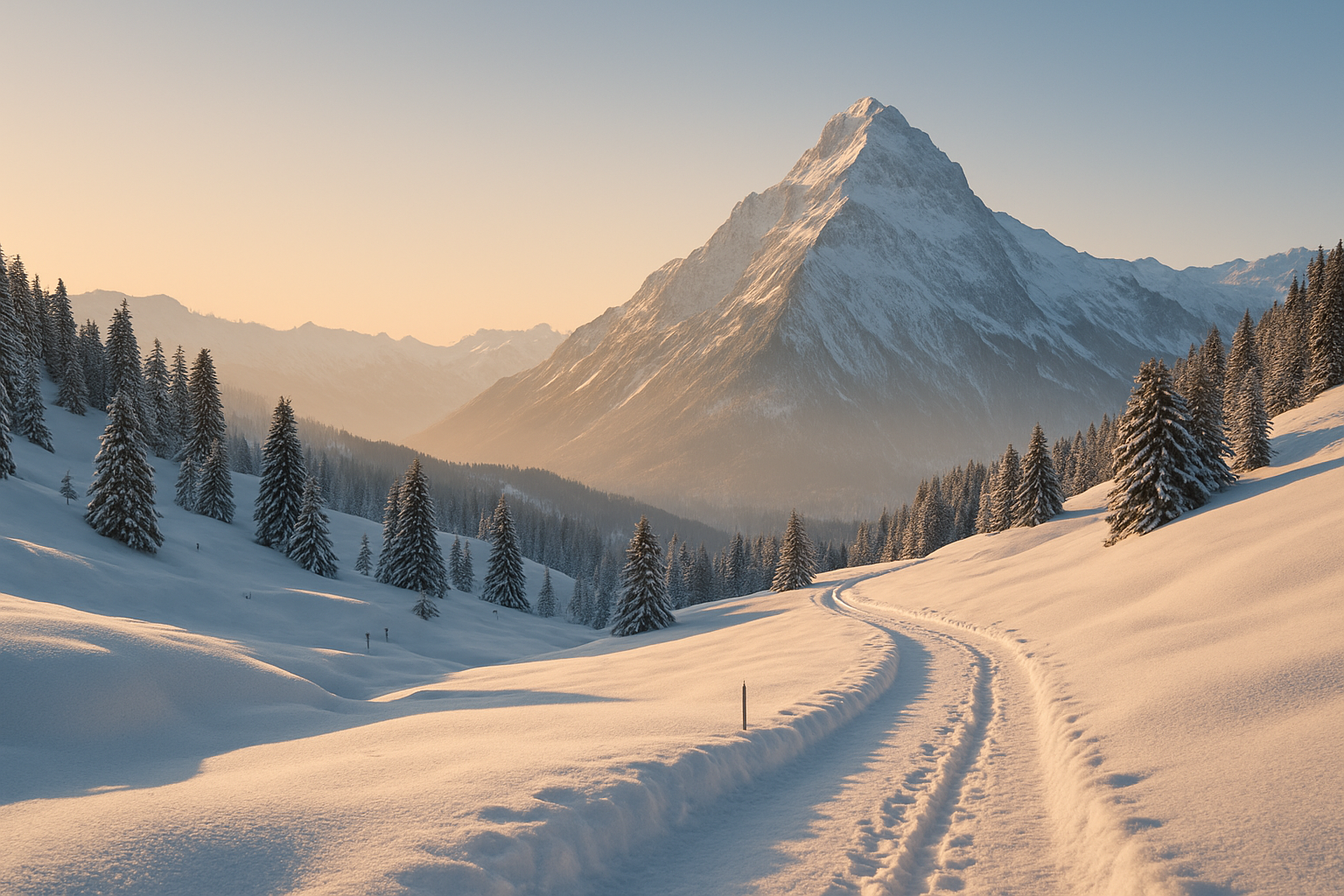
When the first snowflakes blanket the Allgäu landscape, the region transforms into a winter paradise for hiking enthusiasts. Winter hikes in the Allgäu are more than just an alternative to skiing: they lead you through snow-covered forests, to tranquil lakes, and along scenic high-altitude trails with opportunities to stop at cozy mountain huts. Whether you prefer a leisurely stroll to the Alpe Oberdorf or daring to tackle the challenging hike to the Grünten mountain – here you'll find inspiration for your next winter adventure. In this article, we'll show you the best winter hikes in the Allgäu, including tips on safety, equipment, and tour planning.
- Introduction: Why winter hiking in the Allgäu region?
- Winter hikes for beginners
- Winter routes for advanced climbers
- Snowshoeing in the Allgäu
- Equipment & Safety for Winter Hiking
- Comparison: An overview of the best winter hikes in the Allgäu region
- Avoiding Mistakes & Pro Tips
- FAQ: Frequently asked questions about winter hiking in the Allgäu region
- Conclusion
Introduction: Why winter hiking in the Allgäu region?
Magic of the Allgäu winter landscape
The Allgäu Alps are among the most beautiful regions in Germany – especially in winter. The snow muffles every sound, the peaks glitter in the morning sun, and many hiking trails are specially prepared for winter. Whether you hike through the snow-covered Gunzesried Valley or gaze out over the Tegelberg Panorama Trail – winter hiking in the Allgäu means peace, relaxation, and pure nature.
Advantages over other winter sports
Compared to skiing or snowboarding, winter hikes require less equipment, offer more flexible planning, and don't require a lift ticket. Furthermore, winter hikes are significantly easier on the joints and suitable for all ages. Circular routes that combine refreshments and tobogganing opportunities are particularly popular – ideal for leisurely hikers and families.
Best time to travel for winter hikers
The best time for winter hiking in the Allgäu region is between December and March. Particularly stable snow conditions and wonderful light conditions can usually be found from mid-January to the end of February – the ideal time for a break in the wintery Allgäu.
- Reasons for winter hiking in the Allgäu:
- Well-signposted winter hiking trails
- Impressive views of the Alpine panorama
- Cozy places to stop for refreshments
- Diverse tours for every fitness level
Winter hikes for beginners
Easy tours: Perfect for beginners
Are you looking for leisurely winter hiking routes in the Allgäu region that don't require any special equipment? Then the following tours are ideal:
Winter hike to the Oberdorf alpine pasture
Starting point: Gunzesried (Säge parking lot)
Elevation gain: approx. 150 m
Duration: 1.5 hours round trip
Difficulty: easy
The sunny route leads you along a groomed path through the Gunzesried valley to the cozy Oberdorf alpine pasture – perfect for a winter walk with a stop at the hut. Thanks to its south-facing aspect, the path is often easily walkable even after fresh snowfall.
Winter hike to the Buchenberg Alm
Starting point: Buching (Buchenbergbahn valley station)
Elevation gain: approx. 200 m
Duration: approx. 2 hours round trip
Difficulty: easy
A highlight in the Ostallgäu region: From the parking lot, take the winter trail to the Buchenberg Alm. At the top, a cozy mountain hut awaits you with a view of Neuschwanstein Castle. If you like, you can rent a toboggan for the return trip – ideal for families with children.
Winter hike to the Schwarzenberg pond
Starting point: Oberstaufen, Weißach
Elevation gain: approx. 100 m
Duration: 1.5 – 2 hours
Difficulty: easy
A true insider tip in the West Allgäu region: This approximately 6 km long tour takes you along a groomed, family-friendly winter trail to the idyllically situated Schwarzenberger Weiher lake. Here you can expect pure natural tranquility – far from the hustle and bustle.
Hörnle Suspension Railway Circular Route
Starting point: Bad Kohlgrub
Elevation gain: 100–200 m
Duration: approx. 2 hours
Difficulty: easy
This signposted circular trail leads to the Hörnlehütte mountain hut, where magnificent views of the Ammer Valley and the Allgäu region await you. The cable car can be used for the ascent or descent (depending on operating hours) – a practical option for those with knee problems or uncertain snow conditions.
Special highlights for leisurely hikers
Those who appreciate a place to stop for refreshments will find both the Buchenberg Alm and the Alpe Oberdorf ideal. Both alpine pastures are open on many days during the winter and offer warm meals, drinks, and panoramic views.
Practical tips for safe introductory hikes:
- Start your tour early – on short days it can get dark quickly.
- Good footwear with a profiled sole is essential – even for easy hikes.
- A thermos of tea provides warmth and motivation on the go.
| tour | Starting point | Length of time | Elevation gain | Place to stop for refreshments | Sledding opportunity |
|---|---|---|---|---|---|
| Alpe Oberdorf | Gunzesried | 1.5 hours | 150 m | ✓ | – |
| Buchenberg Alm | Booking | 2 hours | 200 m | ✓ | ✓ |
| Schwarzenberger Pond | Oberstaufen | 1.5–2 hours | 100 m | – | – |
| Hörnle circular trail | Bad Kohlgrub | 2 hours | 100–200 m | ✓ (Hörnlehütte) | – |
Winter routes for advanced climbers
A bit more challenging: Moderately difficult tours
Winter hike to the Imberger Horn
Starting point: Bad Hindelang (Hornbahn valley station)
Elevation gain: approx. 400 m
Duration: 3 hours total
Difficulty: medium
From the valley station, the winter hiking trail leads steadily uphill to the summit of the Imberger Horn – offering a magnificent view of the Zugspitze. The return journey can be shortened by taking the cable car. Hiking poles are recommended!
Gaisalp via Gaisalpweg (Oberstdorf)
Starting point: Reichenbach near Oberstdorf
Elevation gain: approx. 350 m
Duration: approx. 3 hours
Difficulty: medium
The route leads through forest and the first alpine sections to the rustic Gaisalpe. On a clear day, an impressive view of the Rubihorn awaits. Despite the winter ascent, it is quite manageable with the appropriate equipment.
Panoramic trail on the Tegelberg
Starting point: Tegelberg cable car valley station (Schwangau)
Elevation gain: approx. 300 m
Duration: approx. 2.5 – 3 hours
Difficulty: medium
A true Ostallgäu classic: The wide panoramic trail winds its way across sunny slopes with spectacular views of Neuschwanstein Castle. Caution is advised when there is snow – sturdy footwear with crampons is recommended.
Winter hike to the Falkenhütte (Ofterschwang)
Starting point: Sigiswang near Ofterschwang
Elevation gain: approx. 300 m
Duration: 2.5 hours
Difficulty: easy-medium
Short, cozy, and with a rustic charm: The Falkenhütte is worth a visit even in winter. From the starting point near Ofterschwang, the trail leads up to the hut through snow-covered meadows and forests with beautiful views of the Iller Valley.
- Typical features of these tours:
- Some sections are steeper
- More elevation gain (300–400 m)
- Longer walking times over 2 hours
- Good preparation is required.
Snowshoeing in the Allgäu
What distinguishes snowshoeing from regular tours?
Unlike regular winter hikes, snowshoeing takes you off-trail. You'll enjoy pristine nature, but you should have experience in the terrain and with avalanche conditions.
Snowshoe tour Sonnenkopf – Spicherhalde
Starting point: Fischen/Debringhausen
Elevation gain: 400–500 m
Duration: 3–4 hours
Difficulty: medium
This route is one of the best snowshoe hikes in the Allgäu region. Starting in Fischen, you ascend across open slopes and through tranquil forests to the Sonnenkopf – a magnificent viewpoint.
Winter hike on the Grünten (to Grüntenhütte)
Starting point: Kranzegg or Rettenberg
Elevation gain: 600–700 m
Duration: 4–5 hours
Difficulty: hard
The "Guardian of the Allgäu" is a fantastic experience in winter with snowshoes – but only for experienced hikers with complete winter safety equipment. You'll be rewarded with a breathtaking panoramic view.
Suitable routes & snowshoeing tips
- Always plan with GPS track and map
- Respect wildlife protection and exclusion zones
- No snowshoe hike without a functioning avalanche app
- Snowshoeing – What you need:
- Snowshoes + matching poles
- Gaiters
- GPS track or map & compass
- Experience in terrain and avalanche assessment