


Winter hiking in the Bernese Oberland: Discover the most beautiful routes
Winter hiking in the Bernese Oberland: The most beautiful routes
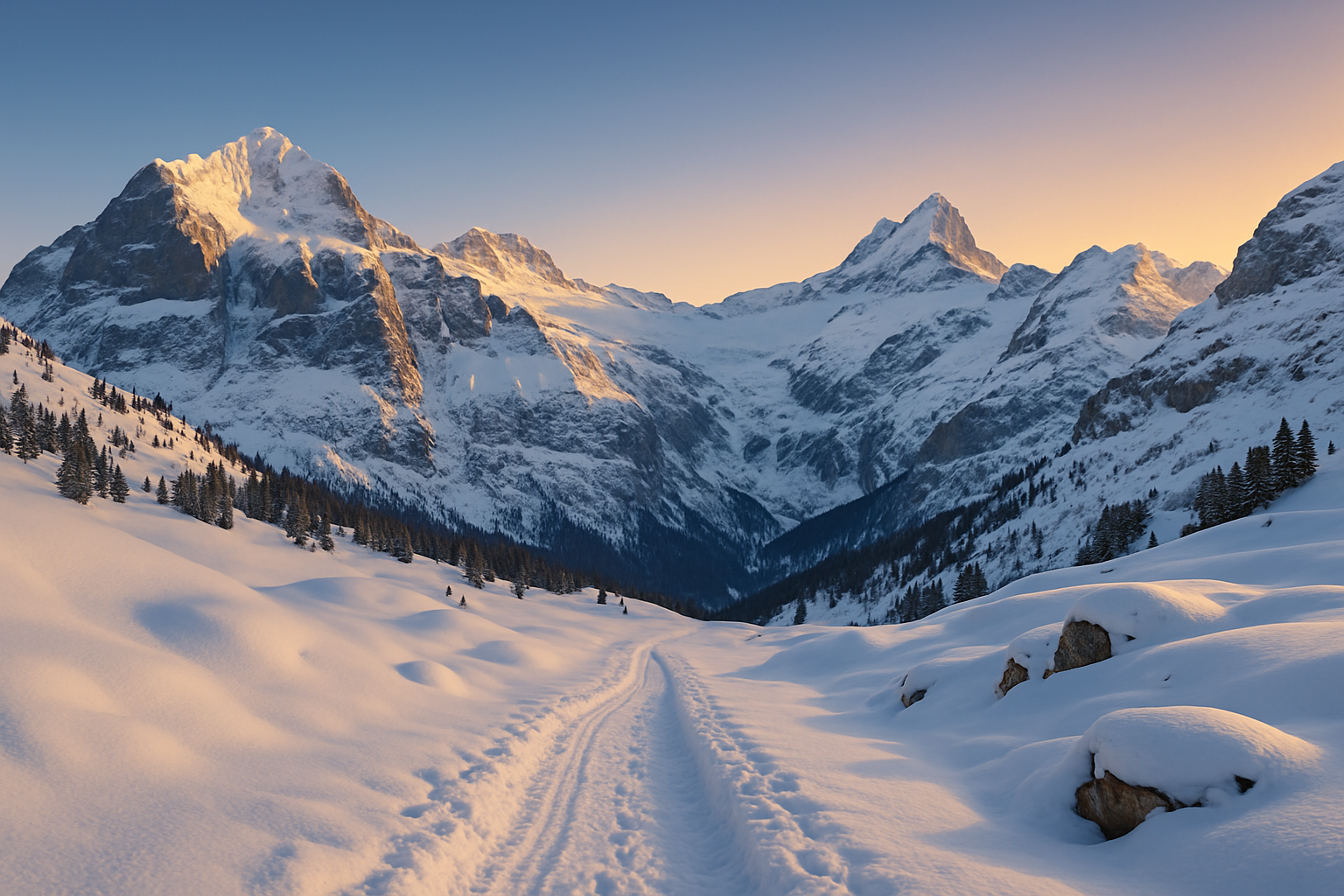
Winter hiking in the Bernese Oberland is more than just exercise in the fresh air – it's a gentle snow adventure with breathtaking views. Between December and March, valleys and highlands transform into a tranquil, glittering world where you can unwind on well-groomed trails. Whether you're a beginner, traveling with family, or an experienced winter hiker seeking an alpine challenge – you'll find suitable tours here. In this article, we present the best winter hiking trails in the Bernese Oberland : including elevation gain, duration, starting point, and regional tips. Start planning your winter holiday in the Bernese Oberland now – with practical information on equipment, safety, and tour planning!
- The best winter hiking trails in the Bernese Oberland
- Difficulty levels: For beginners to experts
- Equipment and preparation
- Staying safe: Avalanches & weather
- Winter hike or snowshoeing?
- Top 5 winter hikes at a glance (comparison table)
- Avoid mistakes – Pro tips from the expert
- FAQ – Frequently Asked Questions about Winter Hiking
- Conclusion: Why winter hiking in the Bernese Oberland is worthwhile
The best winter hiking trails in the Bernese Oberland
Hasliberg Panorama Trail
The Hasliberg Panorama Trail starts at the Käserstatt mountain station high above Meiringen. The hike, which takes 1.5 to 2 hours and covers an elevation gain of approximately 100–150 meters, follows wide paths with fantastic views of the Eiger, Mönch, and Jungfrau peaks. The trail is ideal for children thanks to its gentle inclines and well-marked path. Between December and March, the trail is particularly beautiful – on clear days, the sun shines over the Engelhorn massif and down into the valley.
Winter hike Männlichen – Kleine Scheidegg
This moderate hike is a classic among winter trails in the Bernese Oberland . The starting point is the Männlichen mountain station (accessible by gondola), from where you hike for about 2 hours on well-maintained paths to Kleine Scheidegg. The route descends 200 meters in altitude, with a few short uphill sections. The monumental north faces of the Eiger, Mönch, and Jungfrau are always in view. A tip for sun worshippers and photographers!
Winter hike Axalp – Hinterburgseeli
A hidden gem overlooking Lake Brienz: The winter hike to the frozen Hinterburgseeli lakes begins in Axalp. The loop is moderately difficult, with an elevation gain of approximately 200 meters and a hiking time of 2 to 2.5 hours. The highlight is undoubtedly the snow-framed, often frozen lake at the end of the trail – a mystically beautiful winter moment. Open snow patches also make snowshoeing possible here.
Winter Panorama Trail Adelboden – Tschentenalp
This scenic high-altitude trail starts from the Tschentenalp mountain station (accessible via gondola from Adelboden). The hike takes you 2 to 2.5 hours at an altitude of approximately 250–300 meters through open snow-covered landscapes with stunning views towards the Wildstrubel massif . The refreshment stops at Tschentenalp are cozy and popular – ideal for warming up after your hike. It's especially popular with more active day-trippers.
Walk at Oberstockensee
A picturesque circular trail at an altitude of 1,640 meters – right by the Stockhorn mountain station near Erlenbach in the Simmental valley. The trail circles Lake Oberstocken and is perfect for a family hike in winter . In about 1 to 1.5 hours, you can enjoy a leisurely walk with virtually no elevation gain (less than 100 meters) around the frozen lake. Especially in good weather, you'll be rewarded with panoramic views of the Alps and the Swiss Plateau.
- Hasliberg: Panoramic trail with an elevation gain of over 100 meters, suitable for families
- Männlichen–Kleine Scheidegg: 200 m descent, spectacular mountain views
- Axalp–Hinterburgseeli: Mystical lake, moderate difficulty
- Adelboden–Tschentenalp: 250–300 m elevation gain, restaurants along the way
- Oberstockensee: Circular walk, under 100 meters altitude, ideal for children
Difficulty levels: For beginners to experts
Easy winter hiking trails
- Hasliberg Panorama Trail: Only 100–150 meters of elevation gain, 2 hours, ideal for all ages.
- Bettmeralp – Riederalp: 1 hour via wide paths, with a spectacular view of the UNESCO World Heritage Site Aletsch Glacier.
- Walk around Oberstockensee: Almost no incline, family and senior friendly.
Moderate tours
- Männlichen – Kleine Scheidegg: Ideal for ambitious beginners, moderate descent, 2 hours.
- Winter hike Axalp – Hinterburgseeli: 200 m elevation gain, 2–2.5 hours in open and snowy landscape.
- Adelboden – Tschentenalp: 2–2.5 hours via high-altitude trails with panoramic views and a mountain restaurant.
Challenging routes for experienced climbers
- Schwarzwaldalp – Waldspitz – First: Alpine tour with 600–700 m elevation gain, approximately 4–5 hours walking time – only for experienced hikers!
- Grosse Scheidegg – First: 300 m elevation gain, quite challenging in winter conditions, 3 hours.
| route | Elevation gain | length | Snow conditions (recommended) |
|---|---|---|---|
| Hasliberg Panorama Trail | 100–150 hm | 3–4 km | Dec–Mar |
| Männlichen – Kleine Scheidegg | -200 hm | 4–5 km | Dec–Mar |
| Schwarzwaldalp – First | 600–700 hm | 8–9 km | Jan–Mar |
Equipment and preparation
Essential clothing and equipment
- Insulated, waterproof hiking boots with a grippy sole
- Warm hat and waterproof gloves
- Layered look with breathable layers
Technical aids & maps
- Outdoor GPS app (e.g. Komoot with offline function)
- Printed hiking map of the region
- SLF app for avalanche situation & AV warnings
Thermos flask & Co.: What belongs in your backpack
- 1 liter of hot tea in an insulated bottle
- Sunscreen & sunglasses
- Emergency kit with whistle and headlamp
- Small supply of energy bars
Staying safe: Avalanches & weather
Correctly assessing avalanche dangers
Especially when you're in high alpine regions like Tschentenalp or Schwarzwaldalp, avalanche safety is paramount. Pay attention to the daily bulletin at www.slf.ch , find out about the danger levels, and stay on marked trails.
Check and interpret the weather situation
Use MeteoSwiss, Bergfex, or the "Alpenwetter" app. Be cautious in case of increasing wind, fog, or heavy snowfall – especially on tours above 1500 m.
Emergency measures in alpine terrain
- Fully charge mobile phone & activate emergency app
- Tell someone the route
- Follow the marked paths and never cross untracked areas.
Winter hike or snowshoeing?
Differences in technology and route selection
Winter hiking means comfortable walking on groomed trails – you don't need any special technique for that. Snowshoeing, on the other hand, allows you to venture off the beaten track, especially after fresh snowfall. A certain level of fitness and good orientation skills are required.
Who is snowshoeing suitable for?
If you want to get away from the crowds and experience nature up close, snowshoeing is ideal. The Grütschalp – Mürren route is particularly suitable, as you can choose between a groomed winter trail and a free snowshoe tour.
Recommended snowshoe hikes in the Bernese Oberland
- Grütschalp – Mürren: 150 m elevation gain, 1.5–2 hours; alternative route possible in deep snow
- Engstligenalp circular trail: open high plateau, ideal for first snowshoeing experiences
| feature | Winter hiking | Snowshoeing |
|---|---|---|
| path | Prepared / marked | Unmarked route |
| equipment | Winter boots, walking sticks | + Snowshoes, gaiters |
| Suitable for | Beginners & Families | Experienced hikers with a sense of direction |
Top 5 winter hikes at a glance (comparison table)
| route | difficulty | Length of time | Elevation gain | panorama | Places to eat and drink | Publicly accessible |
|---|---|---|---|---|---|---|
| Hasliberg Panorama Trail | Light | 1.5–2 h | 100-150 | ⭐⭐⭐⭐⭐ | Yes | Yes |
| Männlichen – Kleine Scheidegg | Medium | 2 h | -200 | ⭐⭐⭐⭐⭐ | Kleine Scheidegg train station | Yes |
| Bettmeralp – Riederalp | Light | 1 h | 100 | ⭐⭐⭐⭐ | Yes | Yes (gondola) |
| Schwarzwaldalp – First | Difficult | 4–5 h | 600–700 | ⭐⭐⭐⭐ | Only stopovers | Limited |
| Adelboden – Tschentenalp | Medium | 2–2.5 h | 250–300 | ⭐⭐⭐⭐ | Yes | Yes |
The most important information at a glance
- The Bernese Oberland offers routes for every experience level – from short & easy to alpine & challenging.
- Best time for winter hikes: mid-December to early March
- With good equipment, a checklist, and planning, winter hiking becomes safe and enjoyable.
- Many routes are also easily accessible by public transport.
- Panoramic views guaranteed: Almost every route offers breathtaking views.
Avoid mistakes – Pro tips from the expert
The most common beginner mistakes
- Too late a start time: It gets dark early in winter!
- Inadequate clothing – especially dangerous in wind chill conditions
- Avalanche situation ignored – critical even on well-known paths
Our must-haves for every winter excursion
- Sun protection – snow reflects even when cloudy.
- Spare gloves – often underestimated
- Mini spikes for icy sections (e.g. Axalp)
Tour planning: What professionals do differently
Professionals start early, check live information multiple times (e.g., train status, route reports), have a plan B, and never rely solely on their phone's GPS. Whether you're hiking to Tschentenalp or climbing high near Schwarzwaldalp – preparation is everything.
FAQ – Frequently Asked Questions about Winter Hiking
When is the best time for winter hiking in the Bernese Oberland?
Most tours are best undertaken between mid-December and early March. In lower-lying areas like Hasliberg or Aletsch Arena, depending on snow conditions, it's even possible to start as early as November. High-alpine routes, such as those on the Grosse Scheidegg, are generally only suitable from January onwards.
Do I need snowshoes for winter hiking?
On groomed trails like Männlichen – Kleine Scheidegg or the Hasliberg Panorama Trail, you don't need snowshoes. However, in deep snow, for example on Axalp – Hinterburgseeli or Engstligenalp, snowshoes offer added comfort and safety.
What to do if the weather suddenly turns bad?
Turn back immediately! Always plan with extra time and alternative return routes. Check with mountain railways or your accommodation provider beforehand – and note down important emergency numbers such as the Alpine emergency number 1414.
Can I go winter hiking with children?
Absolutely! Short, safe hikes like the walk around Lake Oberstocken or the easy Hasliberg panoramic trail are perfect. Make sure you pack warm clothing, plenty of breaks, and some child-friendly surprises in your backpack (e.g., a warm drink, a snack).
Are the paths avalanche-safe?
Marked winter hiking trails in the Bernese Oberland are generally avalanche-safe – for example, Tschentenalp or Bettmeralp. Nevertheless, always check the avalanche bulletin at www.slf.ch and heed warning signs!
How do I find current road conditions?
Regional tourism portals such as myjungfrau.ch or berneroberland.ch provide daily updates on groomed trails, closures, and snow depths. Alternatively, mountain huts and local Facebook groups can offer further information.
Conclusion: Why winter hiking in the Bernese Oberland is worthwhile
Whether you want to spend time with family, unwind, or challenge yourself physically – in the Bernese Oberland you'll find winter hikes that are just right for you. From peaceful panoramic loops like those around Hasliberg to challenging alpine routes near Schwarzwaldalp – the combination of accessibility, nature, and views is unique. Thanks to excellent infrastructure, safe trails, and a magnificent backdrop, you'll experience a winter deceleration that has become rare. So, pack your hiking poles and discover Switzerland at its finest!
Find more Alpine inspiration at Alpsland – sustainable hoodies, T-shirts & accessories for mountain lovers.