


Snowshoeing in the Allgäu: The best winter routes
Snowshoeing in the Allgäu: The best routes in winter
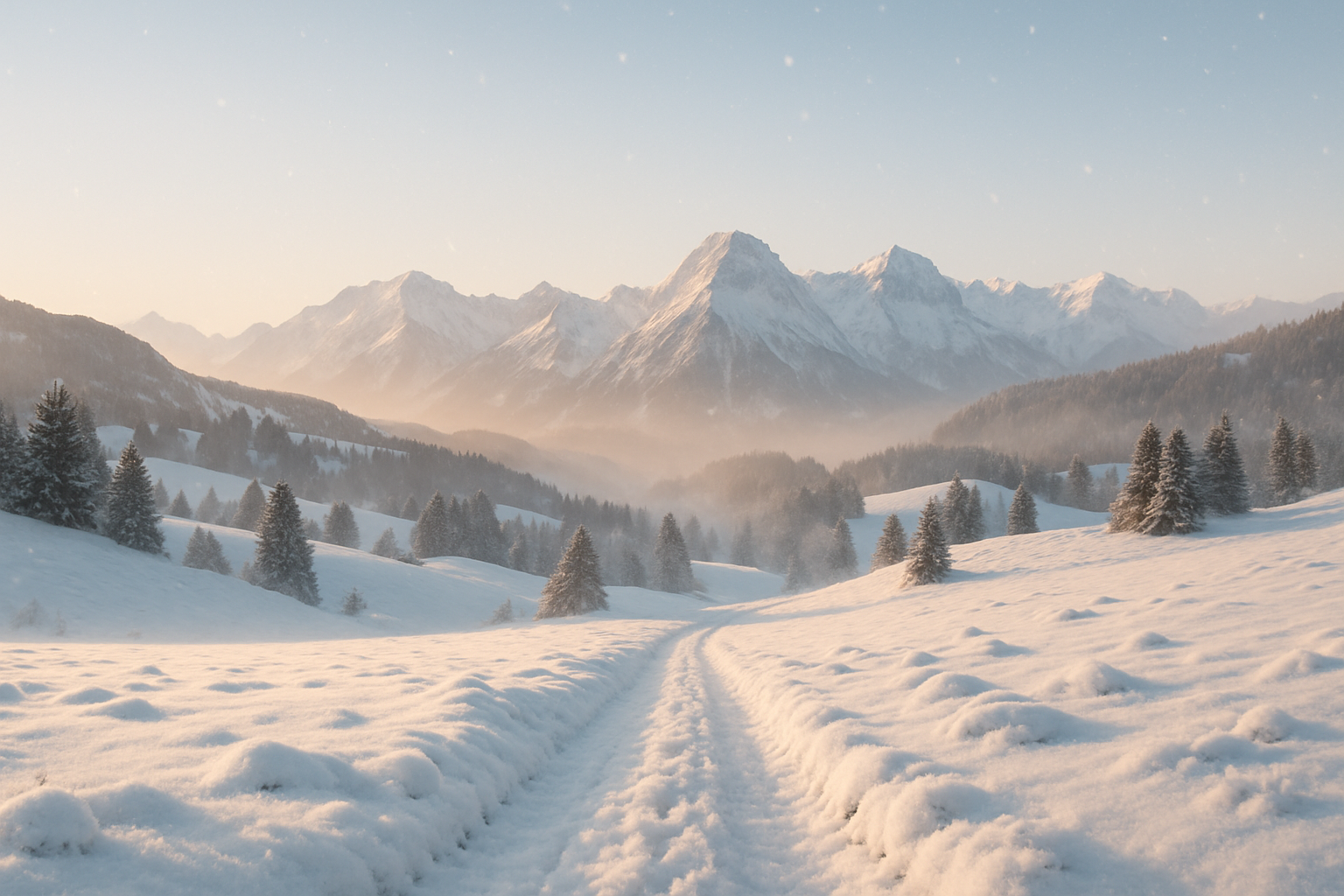
The Allgäu winter isn't just for skiers – it's also a paradise for anyone wanting to discover the tranquil winter wonderland on foot. With snowshoes, you can hike through snow-covered valleys, climb peaks, or explore silent forests. Whether you're a beginner or an experienced mountaineer, this guide will show you the most beautiful snowshoe hikes in the Allgäu – including elevation gain, difficulty level, duration, and special features. Look forward to classics like the Wertacher Hörnle or alpine routes like the Hirschberg. Plus: a packing list, safety tips, and information on snowshoe rentals!
- 1. Why snowshoeing in the Allgäu region?
- 2. The most beautiful snowshoe hikes in the Allgäu
- 3. Tour comparison: Difficulty, duration and elevation gain
- 4. Equipment: What you need for snowshoeing
- 5. Safety in winter: What you should pay attention to
- 6. Renting snowshoes in the Allgäu region – Here's how it works
- 7. Common Mistakes & Professional Tips
- 8. FAQ about snowshoeing in the Allgäu
- 9. Conclusion
Why snowshoeing in the Allgäu region?
Winter enjoyment away from the slopes
Snowshoeing reveals a tranquil side of the Allgäu region. Instead of the hustle and bustle of the ski slopes, you can enjoy untouched nature, fresh air, and the crunch of snow under your feet. Whether you trek through snow-covered forests or climb open slopes, every tour is a winter nature experience. The views on the Hörnerbahn summit loop or across the vast snowfields of the Schönkahler are particularly impressive.
Suitable for all levels
Whether you want to hike with children (e.g., the marked Söllereck Trail) or are looking for an alpine challenge (like the route via the Alpe Stubental to the Hirschberg): In the Allgäu region, you'll find snowshoe tours for all abilities. Many routes start conveniently from cable car stations or parking lots, making spontaneous tours possible.
Healthy exercise in nature
Snowshoeing improves your stamina, enhances your balance, and helps you shake off the winter blues. The slow pace and consistent exertion also make it ideal for unwinding – for example, on a leisurely hike around the Scheuenalpe in Balderschwang.
- No prior knowledge required
- Low equipment costs
- Individually plannable
- Intense nature experience
The most beautiful snowshoe hikes in the Allgäu region
For beginners: Easy tours with little elevation gain
Hörnerbahn summit circuit
Region: Hörnergruppe, Bolsterlang | Starting point: Hörnerbahn valley station
A perfect introductory tour with magnificent panoramic views. Take the Hörnerbahn cable car up to over 1500 m. At the top, a leisurely circular hike awaits you, leading over the Bolsterlanger Horn and, if snow conditions are good, continuing towards the Weiherkopf ( approx. 2–2.5 hours , 300 m elevation gain ). The expansive snowfields and viewpoints are ideal for first-time snowshoeing experiences. Marked and regularly used.
Wertacher Hörnle
Region: Vorderes Allgäu | Starting point: Obergschwend (parking lot)
The Wertacher Hörnle is an Allgäu classic and a perfect summit for beginners: 400 meters of elevation gain , approximately 2–2.5 hours hiking time, a beautiful south-facing slope, and panoramic views extending to the Tannheim Mountains. The gentle ascent leads across open meadows to the summit cross – perfect in sunshine and fresh snow.
Söllereck snowshoe trail
Region: Oberstdorf | Starting point: Söllereckbahn mountain station
An officially marked snowshoe trail for families and beginners with minimal elevation gain ( 200 meters ) and a duration of approximately 1.5 hours . The trail starts conveniently via cable car. It offers stunning views of the Kleinwalsertal valley and is avalanche-safe.
Balderschwang – Round trip to the Scheuenalpe
Region: Balderschwang Valley | Starting point: Balderschwang town center
Relaxed, scenically stunning, and barely steep: the Scheuenalpen circuit is ideal for leisurely winter hikers. The 1.5–2 hour route leads through pristine valleys and past old alpine huts – 250 meters of elevation gain , no special skills required.
| tour | Length of time | Elevation gain | Special features |
|---|---|---|---|
| Hörnerbahn summit circuit | 2–2.5 h | approx. 300 m elevation gain | Scenic loop with cable car access |
| Wertacher Hörnle | 2–2.5 h | approx. 400 m elevation gain | Panoramic summit tour |
| Söllereck Trail | 1.5 h | approx. 200 m | Family-friendly, marked |
| Scheuenalpe circular tour | 1.5–2 h | approx. 250 m elevation gain | Alpine pastures and quiet valleys |
For advanced users: Challenging variations
Round trip to the Gaisalpe (Oberstdorf)
Start: Renksteg parking lot, Oberstdorf | Duration: 3 hours | Elevation gain: 450 meters
This scenic tour leads into a picturesque high valley with a managed mountain hut (partially open). The trail is not always groomed, but easy to walk. Quiet forest sections alternate with open slopes – the Gaisalpe is located at approximately 1,150 m.
Imberger Horn – Sonnenklause Loop
Start: Hornbahn Bad Hindelang | Duration: 3–3.5 hours | Elevation gain: approx. 600 meters
A varied ascent through snow-covered forest paths. The Sonnenklause winter hut is situated on a sunny plateau overlooking the Ostrach valley. Overall, a moderately challenging hike through dense forest.
Schönkahler above Bärenmoos
Start: Bärenmoos parking lot near Wertach | Duration: approx. 3 hours | Elevation gain: 500 meters
Those who love open slopes will love the Schönkahler – ideal after fresh snowfall. The snowfields above the treeline are vast and perfect for practicing technique. Trails are poorly marked, so use GPS tracks!
Bärenköpfle – Gunzesrieder Valley
Start: Ostertalbrücke parking lot | Duration: approx. 3 hours | Elevation gain: 500 meters
This tour in the Nagelfluhkette mountain range offers spectacular views down into the valleys and bizarre groups of trees in the snow. Technically not too difficult, but demanding in terms of fitness. Recommended only in safe snow conditions.
For experts: Alpine challenges
Hinterstein – Alpe Stubental – Hirschberg
Start: Parking lot “Auf der Höh” in Hinterstein | Duration: 4–5 hours | Elevation gain: 700–800 meters
Alpine solitude awaits in the remote Ostrach Valley: The trail leads through forests and steep slopes, past the Stubental alpine pasture, to the panoramic Hirschberg summit. Only accessible with a complete avalanche transceiver set and alpine experience.
Nebelhorn snowshoe route
Start: Nebelhorn cable car valley station, Oberstdorf | Duration: 4–5 hours (depending on the route) | Elevation gain: 600–900 meters
Whether to the Seealpe-Haus or up to the Höfatsblick viewpoint: This route is steep, exposed, and only suitable for experienced snowshoe hikers with top-notch equipment. Fantastic views guaranteed.
Tour comparison: Difficulty, duration and elevation gain
| Tour name | difficulty | Elevation gain | Length of time | region | Avalanche danger | Parking / Public Transport |
|---|---|---|---|---|---|---|
| Hörnerbahn summit circuit | light | 300 hm | 2–2.5 h | Oberallgäu | small amount | easily accessible |
| Gaisalpe | medium | 450 m | 3 h | Oberstdorf | medium | Renksteg parking lot |
| Hirschberg | difficult | 800 hm | 4.5 h | Hinterstein | high | Limited availability |
| Söllereck Trail | light | 200 hm | 1.5 h | Söllereck | small amount | cable car station |
| Bärenköpfle | medium | 500 m | 3 h | Nagelfluhkette | medium | Ostertal Bridge parking lot |